
The Birth of Kaapsehoop
How an empty survey block on the Berlin plateau became a gold-rush village with a Government — in a single dozen years.
Kaapsehoop begins not with gold, but with paper.
Twelve years before the first prospector pegged a claim on the plateau, a government surveyor had already drawn the ground into the record of the South African Republic. What happened between that survey and the arrival of a permanent Gold Commissioner — barely more than a decade later — is the founding story from which every other Kaapsehoop story grows: the gold, the buildings, the cemetery, the people, the wars that followed.
It is also the most tangled part of the mountain’s history. Two names, two settlements and a shifting population have been confused ever since. This page keeps them apart, tells only what the record supports, and says so plainly where the evidence runs out.
The land on paper, 1870
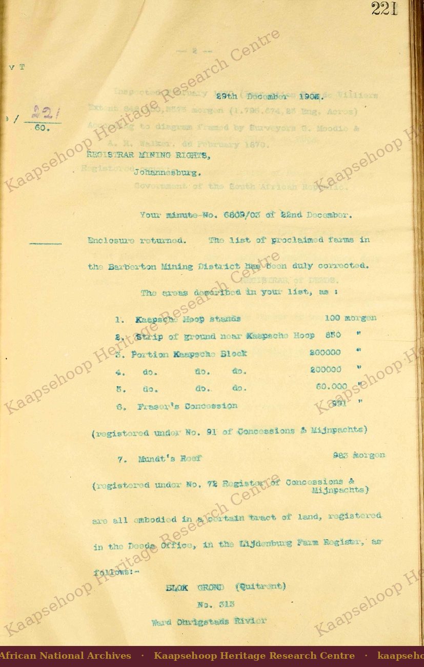
Long before there was a village, the high country south of the Crocodile River was surveyed as a single immense block of state land. In February 1870 a government inspector, P. D. de Villiers, signed off a survey diagram drawn by the surveyors G. Moodie and A. H. Walker: Blok Grond No. 313, in the Ward of the Ohrigstad River — some 848,400 morgen, roughly 7,300 square kilometres, registered to the Government of the South African Republic. The crest itself, where the granite gives way to a long ridge of sandstone, sits at around 4,800 feet, looking east over a valley that falls away some three thousand feet to the De Kaap below.
The rush reaches the plateau, 1882
The gold that would fill that empty block came late in a wider rush. The alluvial discoveries of 1873 at Lydenburg, Mac Mac and Pilgrim’s Rest had drawn the first prospectors into the Eastern Transvaal, and through the 1870s small parties worked their way toward the De Kaap. By 1882 the wave reached the valley and the Kantoor plateau above it.
Two valley discoveries opened the wider field. In the De Kaap valley, Tom Maclachlan — the man the geologist Penning would record simply as “Lachlan” the next year — found alluvial gold and was granted a £500 reward by the government; his strike is the conventional foundation date for the wider De Kaap field. On the Berlin farm, Bernhard Chomse also found gold on ground then held by a certain M. Albrecht. And on Christmas Day 1882, on the Pioneer Reef near the North Kaap, Auguste Robert — “French Bob,” a former Pietermaritzburg confectioner who had walked forty-five days to the diggings with an ox-wagon and crushers — made the strike that would seed Barberton.
On the plateau itself, gold was found in 1882 — the diggings on the Kantoor that gave the village its reason to exist. It is these plateau workings, not the later river strikes, that Kaapsche Hoop grew around.
The Government arrives — Ziervogel and the office
By the late winter of 1882 the population on the plateau was large enough to need a Government. In August the Republic despatched an Acting Gold Commissioner, Jacob Phillipus Ziervogel, to the new diggings. He carried in his commission the Republic’s formal name for the centre: Kaapsche Hoop. The earliest dated document in the Transvaal Archives from his office is docket R5081/82 of 25 August 1882; a week later, R5082/82 of 1 September carries the formal description — “Goudcommissaris Kaapsche Hoop.”
Here the first of two distinctions runs through the whole founding story. “Kaapsche Hoop” was at once the name of a place and the name of a jurisdiction — the wider De Kaap administrative goldfield the Commissioner answered for. A thing true of the goldfield, with its scattered diggings and floating population, was often not true of the small village on the plateau. The two must be read apart.
A new strike in the river country, 1883
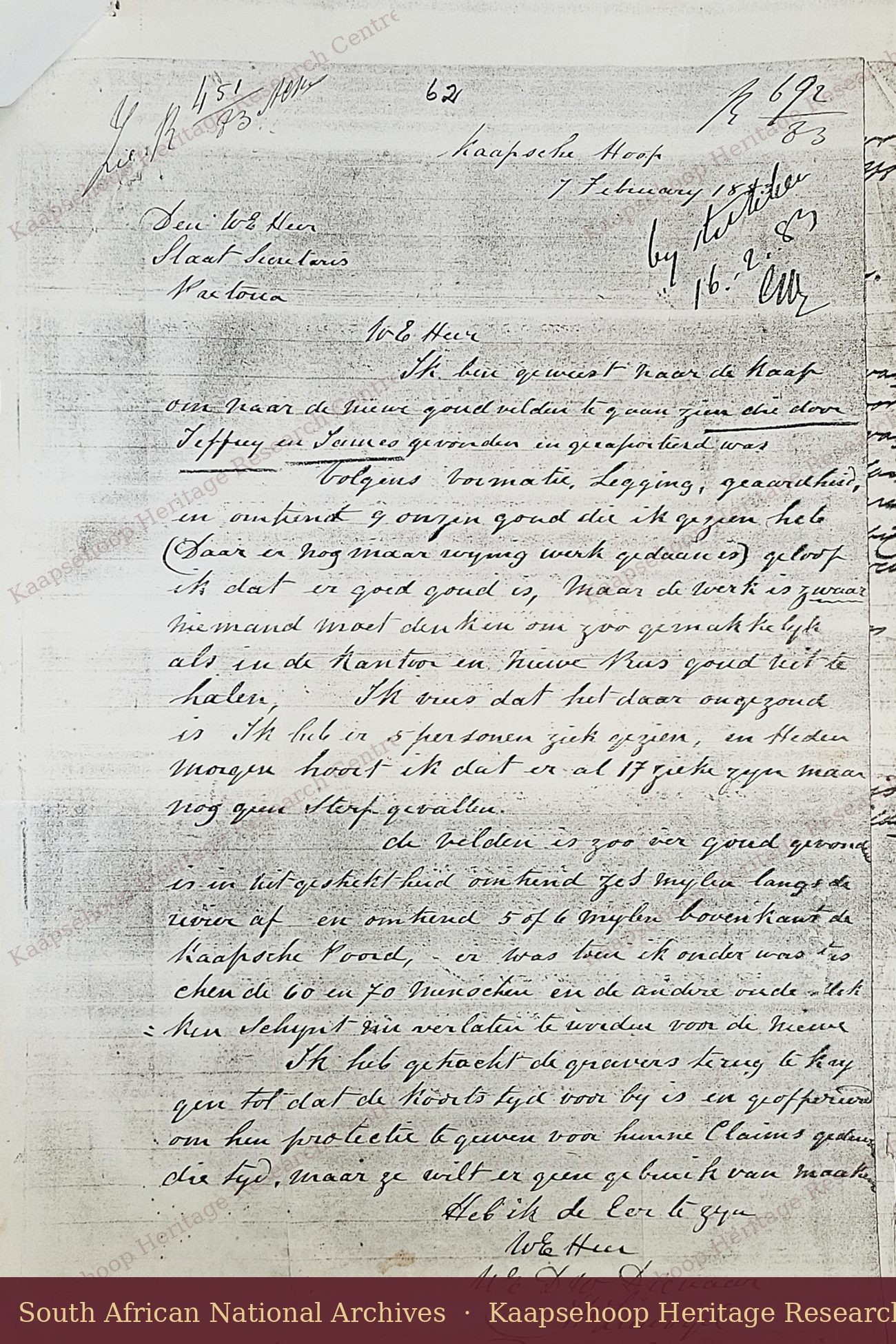
Ziervogel’s first year turned on a strike he did not make — and one that lay well beyond the village. On 27 January 1883 two prospectors, Jeffreys and James, reported a payable find down in the river country, and Ziervogel rode out on 7 February to inspect it. In his own hand he set down what he saw: about nine ounces of gold, “good quality, but the work entails heavy going”; sixty or seventy people already on the ground; five visibly ill, and seventeen sick the next morning. His report documents the movement of diggers away from the plateau and helps distinguish the wider goldfield from the settlement developing at Kaapsche Hoop. The full letter is transcribed and translated below.
Ziervogel to the State Secretary, 7 February 1883
“I have been to the Kaap to inspect the new goldfields found and reported by Jeffrey and James.
Judging by the formation, the lie of the ground and its nature — and the roughly nine ounces of gold I have seen, though very little work has yet been done — I believe there is good gold there. But the work is hard; no one should imagine the gold can be taken out as easily as at the Kantoor and the New Rush. I fear the place is unhealthy: I saw five people sick, and this morning I hear there are already seventeen ill, though no deaths yet.
So far the gold has been found over a stretch of about six miles along the river, and some five or six miles above the Kaapsche Noord. When I was down there, between sixty and seventy people were present, and the older diggings among them seem to be abandoned for the new.
I tried to persuade the diggers to return until the fever season is past, and offered to protect their claims in the meantime — but they will not make use of it.”
Original written in Dutch. Transcribed and rendered into English by the Research Centre; the translation follows the manuscript closely.That one line keeps the founding story in order. The Jeffreys-James strike was a new field in the fever-ridden river country, part of the wider De Kaap goldfield — not the founding of the plateau village, whose own diggings were already established when Ziervogel wrote. It was, rather, the strike that pulled diggers off the plateau and down toward the camp that became Jamestown.
Jamestown, and the pull of the river country
Here the second distinction matters most. The camp that grew in the river country became Jamestown, a separate settlement with its own founders; Dennis Edwards’s 1890 gold-fields guide names Jeffrey, Robert, James and Alexander among them, on the river the period sources render variously as the Lampogwan, Lepongwana or Lebongwana — the Umlambongwane, or “Little Crocodile River.” The camp’s name most likely honoured the James of that roster. Jamestown is not Kaapsche Hoop. It was a short-lived diggers’ camp: by 1890 the same guide could write that “Jamestown is only a name now, and a solitary hostelry is all that marks the spot.” Kaapsche Hoop, the plateau village with the Commissioner’s office, endured. The two are constantly confused; they should not be.
Through 1883 and into 1884 more diggers chose the river, and the Berlin-farm boundary dispute — which Ziervogel had first protested in September 1882 — pushed still more off the plateau ground. When the traveller Edward Mathers passed through in May 1884, he found the Kantoor “deserted almost to a man.”
A village takes shape, 1884
For all the movement, the village held. In May 1884 a substantive Gold Commissioner, Wilson, finally took over the office that Ziervogel had opened and carried in an acting capacity for the better part of two years. Wood-and-iron houses went up; families arrived; a small economy of stores and saloons formed around the diggings. How many people were on the mountain at the peak cannot be fixed exactly — and the two surviving figures pull in different directions, a matter the evidence panels below take up honestly rather than paper over.
Inventory — Mining Commissioner’s Office, Kaapsche Hoop
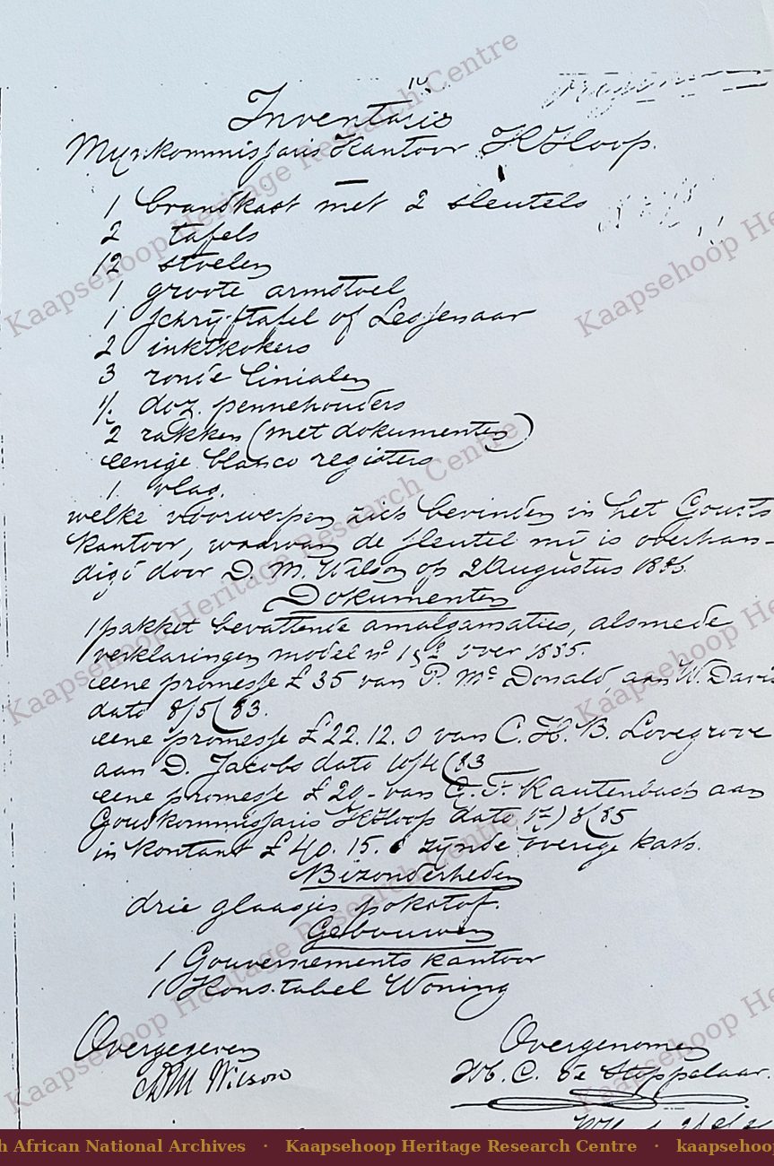
1 safe with 2 keys2 tables · 12 chairs · 1 large armchair1 writing-table or desk · 2 inkwells3 round rulers · ½ dozen penholders2 racks (with documents) · some blank registers1 flag
— objects found in the Government Office, the key of which was handed to me by D. M. Wilson on 2 August 1886.
Documents: a packet of amalgamation returns and declarations for 1885; three promissory notes (£35, £22.12.0 and £21); and £40.15.0 in cash, “being the State’s treasury.”
Particulars: three small glasses of gold-dust. Buildings: one Government Office; one constable’s dwelling.
Handed over: D. M. Wilson · Taken over: M.C. de Stoppelaar · Kaapsche Hoop, 2 August 1886.
Original written in Dutch. Transcribed and translated by the Research Centre.Did You Know?
The whole mountain was a single line on a map before anyone knew it held gold. The ground that became Kaapsehoop was surveyed in 1870 as one state block of about 848,400 morgen — some 7,300 square kilometres — twelve years before the first claim was pegged on it.
Jamestown is only a name now, and a solitary hostelry is all that marks the spot.The Gold Fields of South Africa, 1890
Two Dutch names predate the village: Duivelskantoor (the Devil’s Office) and Kaapsche Hoop (the Hope of the Cape). The record documents when the official name entered use — a Government docket of 1 September 1882 — but not why either name was chosen. Several explanations have been proposed over more than a century; none is confirmed by the archive.
- A homesick Cape digger who saw, in the morning mist off the valley, a likeness of the sea — local tradition (Meiring).
- Dutch hunters and a buck that vanished into “the business-place of Lucifer” — the earliest published version, local tradition (Mathers, 1888).
- A natural “room” of sandstone boulders on the plateau — local tradition, and the feature itself is documented (Penning, 1883).
- The fever-ridden “Valley of Death” below and its “Gates of Hell” — later tradition (Curror, 1964).
- Three further traditions — a fever relocation, a purification rite, and a Spanish derivation (from Aldea Diablo) — recorded in a Kaapschehoop school-history project of the late 1980s; each is local tradition, uncorroborated by the archive.
Several explanations survive, and none is archive-confirmed. On the present evidence, the origin of the name remains unresolved — and the variety of the stories is itself part of the mountain’s character.
The rush-era population cannot be fixed, and the two contemporary figures are in tension with each other.
- G. Wagener counted about 1,000 diggers on the Kantoorberg in 1887 — an in-person count in a contraction year (Wagener, 1890).
- T. J. Ross recalled, from 1905, that the 1882–1888 population had “varied between 8,000 and 3,000” — a figure remembered two decades on (BAAS Guide, 1905).
The two measure different moments — Wagener the settled diggers after the 1886 contraction, Ross the floating peak of the rush years. The truth lies somewhere between; no single figure is documented.
Explore the Kaapsehoop Heritage Archive
The founding is only the first room. Follow the mountain’s story through its gold, its buildings, its people and its wild present.
Enter the Heritage Archive →Heritage & Landscape Protection
The mining features described on this page are part of Kaapsehoop’s historical record. Discover Kaapsehoop does not promote or support prospecting, excavation, the removal of material, or the disturbance of historic workings.
In South Africa mineral rights are vested in the State, and prospecting or mining requires authorisation. Heritage resources — including structures older than sixty years and archaeological material — are protected under the National Heritage Resources Act (No. 25 of 1999). Old workings are also physically dangerous and should never be entered.
Visitors should remain on recognised routes and respect all applicable land-access, environmental and heritage protections. See our Heritage Statement.
Sources
Primary archival sources: Transvaal Archives — Survey Diagram Blok Grond No. 313 (1870); Gold Commissioner dockets R5081/82 and R5082/82 (1882); Gold Commissioner J. P. Ziervogel, inspection letter, 7 February 1883.
Contemporary published sources (1883–1905): J. B. Penning, The Geology of the Kaap Gold Fields (1883); Edward Mathers, Golden South Africa (1888); Dennis Edwards & Co., The Gold Fields of South Africa (1890); H. Dupont, Les Mines d’Or en Afrique du Sud (1890); G. Wagener, Deutsche Rundschau für Geographie (1890); British Association Guide to the Transvaal (1905).
Later historical works: F. E. T. Curror, Eureka City (1964); D. J. Meiring, Dynamite and Daisies (c.1975); Clara Soal, History of Kaapse Hoop (1975).